Updated August 21, 2021 at 8:58 AM ET
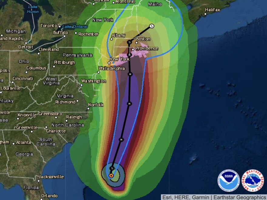
The National Hurricane Center has issued a rare hurricane watch for parts of New England, warning that Tropical Storm Henri will likely develop into a hurricane before making landfall on the northeastern U.S. coast this weekend.
"If Henri strikes southeast New England as a hurricane this weekend, it will be the first direct hurricane landfall since Bob in 1991," National Oceanic and Atmospheric Administration spokesman Chris Vaccaro told NPR.
Henri's maximum sustained winds remained at 70 mph on Saturday, just short of hurricane strength, the NHC said in its 8 a.m. ET update. Hurricanes have sustained winds of at least 74 mph.
The hurricane watch was issued early Friday, covering a large portion of Long Island and areas from New Haven, Conn., to Sagamore Beach, Mass., the National Hurricane Center said. Resort islands such as Block Island, Martha's Vineyard and Nantucket are also in the watch zone.
In addition to strong winds and heavy rain, forecasters are warning of a storm surge that could inundate land with 3 to 5 feet of water.
"Confidence is high that the event will occur Sunday into Monday," the National Weather Service office in Boston said in a briefing early Friday. It added that damaging winds were especially possible east of Henri's track, while rains could cause flooding to the west of the storm's path.
A hurricane watch means that hurricane conditions are possible within the watch area; forecasters normally issue the alerts roughly 48 hours before they expect the first tropical storm-force winds to arrive. The first tropical storm winds from Henri could reach the shore late Saturday.
New England is under its first hurricane watch in years
When the NHC issued its advisory early Friday, "it had been nearly TEN YEARS since a Hurricane Watch has been issued for Southern New England," meteorologist Aaron Perry of NBC Boston said on Twitter.
Henri is expected to bring 3 to 6 inches of rain to eastern Long Island and southern New England, with some areas seeing nearly 10 inches.
"The soil is going to get saturated, in some places it's already saturated," NHC Director Ken Graham said in a midday update on the storm. He added, "Put some winds on top of that, you're going to knock down a lot of trees. You're going to have power outages."
Graham urged residents and travelers to be vigilant, warning of "significant impacts" from Henri.
The hurricane watch for Henri comes just one day after the 30th anniversary of Hurricane Bob's landfall on New England.
Bob wrecked swaths of the coast and knocked out electricity in Cape Cod and other areas — in some cases, for as long as two weeks.
"At least 17 people were killed in the storm, the costliest in New England with more than $1.5 billion in property damage," The Associated Press reports.
Henri's impact will depend on its path and timing
At 11 p.m. ET, Henri was hundreds of miles off the North Carolina coast and moving north.
It's expected to strengthen over the next two days as it traverses very warm waters, likely becoming a hurricane by Saturday. It will then cross the north wall of the Gulf Stream.
"A northward to north-northeastward motion is expected through Saturday, with a turn toward the north-northwest expected late Saturday or Saturday night," the hurricane center said in its 11 p.m. ET forecast. "On the forecast track, Henri is expected to make landfall in Long Island or southern New England late Saturday night or on Sunday."
Hurricane Grace is bearing down on Mexico
People along Mexico's central eastern coast are bracing for the arrival of Hurricane Grace, which has rapidly grown into a major hurricane with sustained winds up to 120 mph, the National Hurricane Center said on Friday.
A hurricane warning is in effect along the coast, from Puerto Veracruz to Cabo Rojo.
"A Hurricane Warning means that hurricane conditions are expected somewhere within the warning area, in this case within 24 hours," the NHC said.
Copyright 2021 NPR. To see more, visit https://www.npr.org.


